Code is located at http://sourceforge.net/projects/t3d2 and the home page is http://t3d2.sourceforge.net/
Applet code snippets Applets
NOAA Redy Sounding Data Analyzer to predict thermal strength NOAA READY
The Earth Google http://earth.google.com KML Interface capabilities
The NASA World Wind
http://worldwind.arc.nasa.gov/ IGC to
World Wind interface capabilities
Airspace OPENAIR txt to kml prototype
Sample Screen Shots of what the code does
Some ideas what the code is supposed to do one day
Code is written in JAVA and JAVA3D. Requires Java 1.4 JRE along with the graphic drivers to make JAVA3D work. Installation Instructions
The 3D Terrain data is DEM - Digital Elevation Model based.
How to create a Flying Site from GTOPO30
Data
How to create a Flying Site from GLOBE
Data
How to create a Flying Site from South
Africa DAT files
How to create a Flying Site from SRTM
Data
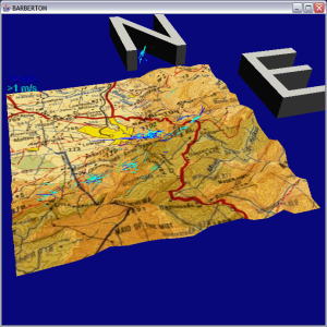
Once you got a Flying Site defined from the DEM data you can view it in 3D using a 3 button mouse.
The 3D Terrain can be displayed in a grid, or with some altitude shading,
or one can apply a scanned in map over it
How to Map Texture onto the terrain
of a Flying Site
One can download from GARMIN eMap, eTrex,. GPS72,. or Log_It,
RobLog, MLR, COMPEO, Aircotec XC-Trainer, Magellan Sportrak,..... your 3D IGC track. GARMIN GPS12 will not work
And then display the track in 3D. Either over a predefined flying site
terrain, or by analyzing the flight and "cutting out" the terrain from
the DEM data.
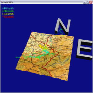
Multiple Tracks that are stored under a flying site can be displayed on top of each other to visual check for thermal trigger points.
When one selects an IGC track from the list of flights at
a certain flying site then the track gets analyzed for thermals.
A thermal is an uninterrupted area of lifted for a certain height.
The minimum height gain textfield allows you to determine what you
accept as a thermal.
Along with the track the thermals get displayed , with the average climbrate
colorcoded.
The picture above shows all the fligts from a competition analyzed for thermals and all the thermals displayed.
The blue/green areas indicate house thermal areas.
If one chooses a Wing then the IGC Track gets analyzed if the
pilot flew optimal.
How to Define a Wing.
This is based on the wing polare information that was chosen when you
selected the wing.
The wind gets determined by the drift from the previous and next thermal.
At the moment an XML file gets created that compares the actual flight with any optimal speed to fly and best glide data derived from the polare of the wing. And 2 new windows get opened showing color coded tracks where the pilot could have improved.
One can activate an animated object to follow the IGC track. And
it shows a View from a Pilot perspective of the flight in very fast motion.
(Which is very confusing)
How to use Animation on a Track
One can add restricted airspace information to a flying site
A Best Turn 2D calculator, to determine the optimal turn in a thermal for a given wing.
This code can also compare 2 wing polare with each other in the 2D view.
http://jflight.sourceforge.net/index.html
Idea is to couple the 2 codes more close once we get a better idea
of where we are heading.
Right now T3D2 is a technology demonstrator to see what can be done
by analyzing 3D track data.
How to use T3D2 for competitions
Frequently Asked Questions FAQ